
// PROJECT · Completed · Aug 2025 – May 2026
VITALS – Visual Intelligent Tactical Assistant for Low-Power Operations
Search-and-rescue agentic base station, sponsored by Lockheed Martin.
Mapping and Planning Agent Owner (Agent D) · UCF Senior Design (Team A39) · Sponsored by Lockheed Martin
- Agents in the SAR architecture
- 4Agents in the SAR architecture
- Configurable power envelope
- 15–60 WConfigurable power envelope
- bge-small-en-v1.5 embeddings
- 384-dimbge-small-en-v1.5 embeddings
- Engineers on the team
- 6Engineers on the team
Overview
Design, develop, and integrate a search and rescue (SAR) system that utilizes autonomous drones and an AI-powered ground control station running on NVIDIA Jetson hardware. The system uses multi-agent intelligence for mission planning, perception, and autonomous control in field-deployable operations.
What I did
- Owned the mapping and planning agent in a 4-agent SAR architecture (vision, retrieval, reasoning, mapping/planning), coordinating over MCP and ACP message contracts, on a 6-engineer team under Lockheed Martin sponsorship.
- Inherited and re-architected the terrain preprocessing pipeline: PostGIS-backed OpenStreetMap queries through SQLAlchemy, EPSG:3857 to EPSG:4326 reprojection, R-tree spatial indexing over a tiled search grid, with per-tile feature classification driving search priority.
- Redesigned multi-drone task allocation from a single greedy heuristic to a two-layer planner: A* global routing over a live costmap plus a local avoidance layer for obstacles absent from the OSM basemap, with non-overlapping timestamped sector assignment for persistent coverage.
- Specified the retrieval subsystem: bge-small-en-v1.5 encoder producing 384-dimensional embeddings into ChromaDB with cosine ranking and metadata filters, and ParquetDB cold archive for events aged out of hot storage.
- Targeted deployment on Jetson AGX Orin 64GB inside a 15–60 W configurable power envelope for disconnected field operation for the base station, and a Jetson Nano configured onto the drone for the vision edge.
Architecture
- Agent A — Vision: YOLOv11 and LLaVA, publishing scene facts over MCP.
- Agent B — Retrieval: ChromaDB with RAG.
- Agent C — Coordinator: LLM runtime on LLaMA 3, emitting ACP intents.
- Agent D — Mapping and Planning: C++/Python planners for maps, costmaps, A*/D*/coverage, and deconfliction.
- MAVLink Router (mavlink-routerd) and a Flask/WebSocket GUI adapter bridging Mission Planner.
- UAV fleet on ArduPilot with Pixhawk 2.4.8 flight controllers.
- Hardware: NVIDIA Jetson AGX Orin (275 TOPS INT8, 64GB LPDDR5, JetPack 6.x, CUDA 12.x, TensorRT 10.x), dual 4S LiPo, RFD900x radios, GPS M8N, and a RealSense depth camera.
Team
Team of 6.
- Justin Gamboa
- Brendan Rodriguez
- Alex Gershfeld
- Giorgio Torregrosa
- Stephen An
- David (Tyler) Jackson
Stack
- Python
- C++
- LangGraph
- YOLO
- NVIDIA Jetson Orin AGX
- Jetson Nano
- ChromaDB
- PostgreSQL
- PostGIS
- SQLAlchemy
- MAVLink
- ArduPilot
- Docker
- Ollama
- LLaMA 3
- CustomTkinter





Timeline
MVP integration milestone
Demonstrated MAVLink-based communication between Jetson ground station and drone.; Generated autonomous mission waypoints through multi-agent collaboration.; Delivered a fully integrated GUI interface linking AI reasoning, terrain mapping, and flight control.
Path planning and terrain pipeline
Develop spatial data ingestion pipeline using OpenStreetMap and PostGIS for terrain awareness.; Implement efficient path planning algorithms that respect drone constraints, terrain, and real-time telemetry.; Design coverage search patterns for multi-UAV coordination and obstacle avoidance.; Integrate geospatial visualization into GUI for operator situational awareness.
Mission architecture and objectives
Operator selects mission type (simulation vs live); Connects to MAVLink drone swarm; Defines Ground Control Station (GCS) location; Draws search polygon and generates terrain grid; Agent D (Mapping & Planning) generates optimized waypoints; Autonomous mission execution with live GUI feedback
Gallery
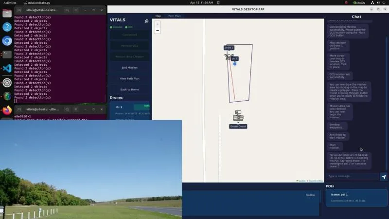
The VITALS desktop application during a mission. 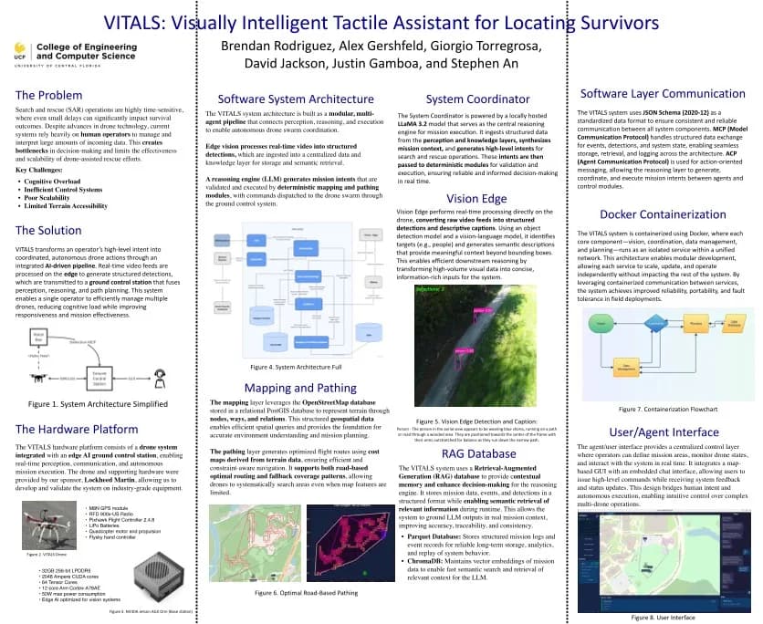
Capstone poster for UCF Senior Design Team A39.